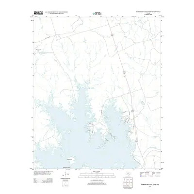
2012 Map of Northeast Lake Kemp
USGS Topo · Published 2012About this map
Lake Kemp dominates the landscape of this portion of Wilbarger County, its complex shoreline defined by numerous inlets and coves that reach into the surrounding Texas plains. The water level at this time reveals landforms like Goat Island and Rattlesnake Island, while the northern reaches of the lake are fed by a network of drainage creeks including Whiskey Cr, Cattle Cr, and Flippin Cr. To the northwest, the Coffee Creek Cow Camp and its adjacent Coffee Cr Cow Camp Lake mark the legacy of ranching in the region.
Find a feature on this map
31 named features on this map. Tap any name to fly to it.
Don’t see what you’re looking for? This feature index may not catch every label — zoom into the map to look around manually.
Map Details
Editions of this 2012 Northeast Lake Kemp Map
This is the sole edition of this map. No revisions or reprints were ever made.
Other maps of this area

1954 · Wichita Falls
USGS Topo · 1:250,000

1958 · Wichita Falls
USGS Topo · 1:250,000

1966 · Franklin Bend
USGS Topo · 1:24,000

1966 · Fulda
USGS Topo · 1:24,000

1966 · Santa Rosa Lake
USGS Topo · 1:24,000

1966 · Grayback
USGS Topo · 1:24,000
1966 · Lake Electra
USGS Topo · 1:24,000

1966 · Northeast Lake Kemp
USGS Topo · 1:24,000

1966 · Southeast Lake Kemp
USGS Topo · 1:24,000

1966 · Northwest Lake Kemp
USGS Topo · 1:24,000