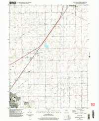
2001 Map of Northeast Pontiac
USGS Topo · Published 2003About this map
Pontiac anchors the southwestern corner of this survey, where the North Fork Vermilion River cuts through the prairie landscape of Livingston County. The map details the transition from the city's parks, such as Dargan Park and Chautauqua Park, to the expansive agricultural grid of Esmen, Odell, and Owego townships. Transportation history is etched into the terrain, visible in the diagonal path of the Old Railroad Grade and the presence of aviation facilities like the Municipal Airport and the private Schott Landing Strip.
Find a feature on this map
28 named features on this map. Tap any name to fly to it.
Don’t see what you’re looking for? This feature index may not catch every label — zoom into the map to look around manually.
Map Details
Editions of this 2001 Northeast Pontiac Map
This is the sole edition of this map. No revisions or reprints were ever made.
Other maps of this area

1935 · Pontiac
USGS Topo · 1:62,500

1939 · Pontiac
USGS Topo · 1:62,500

1947 · Cullom
USGS Topo · 1:62,500

1948 · Dwight
USGS Topo · 1:62,500

1949 · Cullom
USGS Topo · 1:62,500

1950 · Dwight
USGS Topo · 1:62,500

1958 · Odell
USGS Topo · 1:62,500

1958 · Aurora
USGS Topo · 1:250,000

1958 · Peoria
USGS Topo · 1:250,000

1961 · Aurora
USGS Topo · 1:250,000