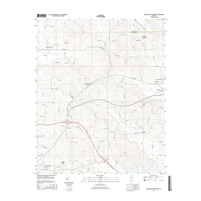
2015 Map of Northeast Pontotoc
USGS Topo · Published 2015About this map
Ecru and the northern outskirts of Pontotoc anchor this survey of the Mississippi hill country, where the landscape is defined by the headwaters of Coonewah Cr and Mubby Cr. Small, established communities like Cherry Creek, Nixon, and Longview are connected by a network of winding local roads such as Tuscumbia Rd and Old Highway 9. The area's social history is preserved through numerous rural burial grounds, including Harmony Cem, Miller Cem, and Immanuel Cem, often located near crossroads or high ground like Dozier Hill. The geography transitions from the flatlands of Connewah Bottom to the rising terrain of Oak Hill, illustrating the traditional settlement patterns where homes and farms followed the ridges above the flood-prone bottoms of Wilson Bottom.
Find a feature on this map
107 named features on this map. Tap any name to fly to it.
Don’t see what you’re looking for? This feature index may not catch every label — zoom into the map to look around manually.
Map Details
Editions of this 2015 Northeast Pontotoc Map
This is the sole edition of this map. No revisions or reprints were ever made.
Other maps of this area

1949 · New Albany
USGS Topo · 1:62,500

1951 · New Albany
USGS Topo · 1:62,500

1955 · Sherman
USGS Topo · 1:62,500

1956 · Tupelo
USGS Topo · 1:250,000

1958 · Tupelo
USGS Topo · 1:250,000

1966 · Troy NW
USGS Topo · 1:24,000

1966 · Bissell
USGS Topo · 1:24,000
1972 · Southwest Pontotoc
USGS Topo · 1:24,000

1980 · Northwest Pontotoc
USGS Topo · 1:24,000

1980 · New Albany West
USGS Topo · 1:24,000