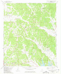
1980 Map of Northeast Pontotoc
USGS Topo · Published 1981About this map
The boundary between Union and Pontotoc counties runs through this landscape of rolling hills and creek bottoms as it appeared in the late 1970s. The northern portion is defined by the headwaters of Springs Creek and the settlement of Poplar Springs, while the southern reaches contain the city of Pontotoc and the notable Old Natchez Trace Park. Several small community centers like Cherry Creek and Endville are mapped alongside numerous rural institutions, including Naylor Chapel and Center Hill Ch. The physical geography is marked by expansive lowlands such as Coonewah Creek Bottom and Wilson Bottom, providing a detailed look at the drainage patterns of North Mississippi. Genealogy interests are well-served by the inclusion of established burial grounds like Harmony Cem, Miller Cem, and Spring Hill Cem, which anchor the various townships and family lands across the quadrangle.
Find a feature on this map
44 named features on this map. Tap any name to fly to it.
Don’t see what you’re looking for? This feature index may not catch every label — zoom into the map to look around manually.
Map Details
Editions of this 1980 Northeast Pontotoc Map
This is the sole edition of this map. No revisions or reprints were ever made.
Other maps of this area

1949 · New Albany
USGS Topo · 1:62,500

1951 · New Albany
USGS Topo · 1:62,500

1955 · Sherman
USGS Topo · 1:62,500

1956 · Tupelo
USGS Topo · 1:250,000

1958 · Tupelo
USGS Topo · 1:250,000

1966 · Troy NW
USGS Topo · 1:24,000

1966 · Bissell
USGS Topo · 1:24,000
1972 · Southwest Pontotoc
USGS Topo · 1:24,000

1980 · Northwest Pontotoc
USGS Topo · 1:24,000

1980 · New Albany West
USGS Topo · 1:24,000