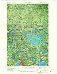
1971 Map of Northome North
USGS Topo · Published 1974About this map
Pine Island State Forest dominates this northern Minnesota landscape, characterized by an intricate network of wetlands and small water bodies. The transition from the dense woodlands of the forest to the outskirts of Northome is marked by the presence of the Northome Municipal Airport and the recreational grounds of Bartlett Lake Park. The region's drainage is defined by several meandering waterways, including Elm Creek, Hoover Creek, and the South Branch Battle River, which weave through the timberland.
Find a feature on this map
15 named features on this map. Tap any name to fly to it.
Don’t see what you’re looking for? This feature index may not catch every label — zoom into the map to look around manually.
Map Details
Editions of this 1971 Northome North Map
This is the sole edition of this map. No revisions or reprints were ever made.
Other maps of this area

1919 · Lundgren
USGS Topo · 1:62,500

1919 · Gemmell
USGS Topo · 1:62,500

1919 · Norden
USGS Topo · 1:62,500

1919 · Bridgie
USGS Topo · 1:62,500

1924 · Bridgie
USGS Topo · 1:62,500

1954 · Bemidji
USGS Topo · 1:250,000

1954 · Roseau
USGS Topo · 1:250,000

1957 · Roseau
USGS Topo · 1:250,000

1957 · Bemidji
USGS Topo · 1:250,000

1958 · Bemidji
USGS Topo · 1:250,000