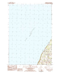
1983 Map of Northport NW
USGS Topo · Published 1984About this map
Lake Michigan dominates this coastal survey, where the northwest edge of the Leelanau Peninsula meets the open water. The shoreline is defined by stretches of sand and the prominent landing at Peterson Park, which serves as a recreational anchor for the area. Moving inland from the coast, the terrain rises toward Braman Hill, overlooking a network of rural roads that supported the local community in the late 1970s and early 1980s. The settlement of Garthe and the nearby Christmas Cove illustrate the historical land use patterns of this coastal region, where small-scale development is concentrated along thoroughfares such as Peterson Park Road and Garthe Road. This map provides a clear record of the peninsula's character before modern expansion, capturing the boundaries of the Northport Corp Bdy as they stood during this era.
Find a feature on this map
16 named features on this map. Tap any name to fly to it.
Don’t see what you’re looking for? This feature index may not catch every label — zoom into the map to look around manually.
Map Details
Editions of this 1983 Northport NW Map
This is the sole edition of this map. No revisions or reprints were ever made.
Other maps of this area

1955 · Cheboygan
USGS Topo · 1:250,000

1956 · South Fox Island
USGS Topo · 1:62,500

1957 · Northport
USGS Topo · 1:62,500

1958 · Cheboygan
USGS Topo · 1:250,000

1983 · Northport
USGS Topo · 1:25,000

1983 · Omena
USGS Topo · 1:24,000
1983 · Gills Pier
USGS Topo · 1:25,000
1983 · Leland
USGS Topo · 1:25,000

1984 · Charlevoix
USGS Topo · 1:100,000
2011 · Northport
USGS Topo · 1:24,000