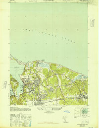
1947 Map of Northport
USGS Topo · Published 1947About this map
Northport and its deep-water harbor define this mid-century coastal survey, showing the transition from established maritime village life to an expanding suburban corridor. The village core is densely detailed with landmarks like the Northport Yacht Club and St Philip Neri Sch, while the shoreline features the industrial Henry Steers Gravel Pit and the expansive W K Vanderbilt Estate overlooking the water. To the east, the landscape becomes more natural and institutional, centered around the large Veterans Bureau Hospital complex and the developing community at Kings Park. Local infrastructure is anchored by the Port Jefferson Branch railroad, which fostered growth in East Northport. The shoreline is characterized by significant public spaces like Sunken Meadows State Park and Crab Meadow Beach Park, marking the area's importance for recreation and North Shore residential appeal during the post-war era.
Find a feature on this map
36 named features on this map. Tap any name to fly to it.
Don’t see what you’re looking for? This feature index may not catch every label — zoom into the map to look around manually.
Map Details
Editions of this 1947 Northport Map
This is the sole edition of this map. No revisions or reprints were ever made.
Other maps of this area

1891 · Bridgeport
USGS Topo · 1:62,500

1892 · Norwalk
USGS Topo · 1:62,500

1893 · Bridgeport
USGS Topo · 1:62,500

1893 · Norwalk
USGS Topo · 1:62,500

1901 · Northport
USGS Topo · 1:62,500

1902 · Setauket
USGS Topo · 1:62,500

1903 · Northport
USGS Topo · 1:62,500

1904 · Setauket
USGS Topo · 1:62,500

1904 · Islip
USGS Topo · 1:125,000

1919 · Setauket
USGS Topo · 1:62,500