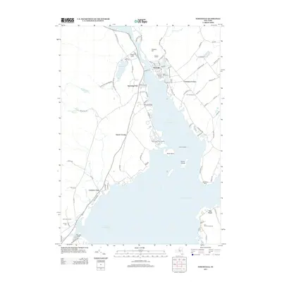
2013 Map of Northville
USGS Topo · Published 2013About this map
Great Sacandaga Lake dominates this 2013 topographic study, illustrating the modern shoreline and recreational geography of the Fulton County region. The village of Northville sits at the northern terminus of the lake where the Sacandaga River enters, serving as a gateway to the Adirondack Park Preserve. Local genealogy is well-documented through several historic burial grounds, including the Main Street Cem, Prospect Hill Cem, and the more remote Gifford Valley Cem. Settlement patterns follow the water, with older communities like Cranberry Creek and Fish House positioned along the western and eastern shores. Notable landforms such as Mead Island and the Kenyon Islands punctuate the reservoir's expanse, while the Northampton Beach Campsite indicates the area's transition toward a leisure economy. Modern infrastructure is represented by the Osbourne Bridge, which connects the disparate shorelines and smaller crossroads like Carpenters Corners.
Find a feature on this map
97 named features on this map. Tap any name to fly to it.
Don’t see what you’re looking for? This feature index may not catch every label — zoom into the map to look around manually.
Map Details
Editions of this 2013 Northville Map
This is the sole edition of this map. No revisions or reprints were ever made.
Other maps of this area

1899 · Broadalbin
USGS Topo · 1:62,500

1902 · Broadalbin
USGS Topo · 1:62,500

1903 · Gloversville
USGS Topo · 1:62,500

1907 · Lake Pleasant
USGS Topo · 1:62,500

1910 · Stony Creek
USGS Topo · 1:62,500

1943 · Gloversville
USGS Topo · 1:62,500

1945 · Edinburg
USGS Topo · 1:24,000
1945 · Galway
USGS Topo · 1:24,000

1945 · Northville
USGS Topo · 1:24,000
1945 · Jackson Summit
USGS Topo · 1:24,000