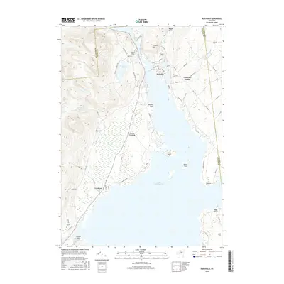
2016 Map of Northville
USGS Topo · Published 2016About this map
Great Sacandaga Lake dominates the southern landscape of this Fulton County region, where the Sacandaga River flows through a narrow valley past the village of Northville. The local geography is defined by water and high ground, from the wetlands of Tamarack Swamp to the elevation of Prospect Hill. Several historic burial grounds are preserved across the area, including Gifford Valley Cem, Prospect Hill Cem, and the Main Street Cem within the village. Smaller hamlets and junctions like Fish House, Carpenters Corners, and Cranberry Creek mark the periphery of the lake, illustrating the settlement pattern of the southern Adirondack foothills. Landforms such as Hampton Point and the Kenyon Islands punctuate the vast reservoir, while family-named landmarks like Sinclaire Point and Paradise Point reflect the area’s long history as a destination for seasonal residence and recreation on the water.
Find a feature on this map
76 named features on this map. Tap any name to fly to it.
Don’t see what you’re looking for? This feature index may not catch every label — zoom into the map to look around manually.
Map Details
Editions of this 2016 Northville Map
This is the sole edition of this map. No revisions or reprints were ever made.
Other maps of this area

1899 · Broadalbin
USGS Topo · 1:62,500

1902 · Broadalbin
USGS Topo · 1:62,500

1903 · Gloversville
USGS Topo · 1:62,500

1907 · Lake Pleasant
USGS Topo · 1:62,500

1910 · Stony Creek
USGS Topo · 1:62,500

1943 · Gloversville
USGS Topo · 1:62,500

1945 · Edinburg
USGS Topo · 1:24,000
1945 · Galway
USGS Topo · 1:24,000

1945 · Northville
USGS Topo · 1:24,000
1945 · Jackson Summit
USGS Topo · 1:24,000