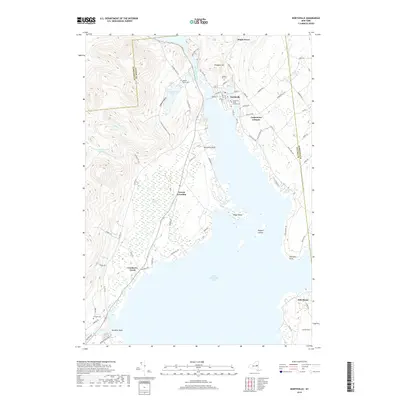
2019 Map of Northville
USGS Topo · Published 2019About this map
Great Sacandaga Lake dominates the southern landscape of this 2019 survey, where the Sacandaga River flows through the village of Northville. The map illustrates the contemporary settlement patterns of northern Fulton County, with the historic center of Northville positioned along the riverbank across from Hampton Point. The area's genealogical history is well-represented through several burial grounds, including the Northville Main Street Cemetery, Prospect Hill Cemetery, and the more secluded Gifford Valley Cemetery. To the west, the terrain rises sharply into the Gifford Valley and around Woodward Lake. Smaller historical settlements and junctions such as Fish House, Cranberry Creek, and Sweets Crossing are mapped alongside modern infrastructure, showing the transition from the high Adirondack foothills to the shores of the massive reservoir.
Find a feature on this map
77 named features on this map. Tap any name to fly to it.
Don’t see what you’re looking for? This feature index may not catch every label — zoom into the map to look around manually.
Map Details
Editions of this 2019 Northville Map
This is the sole edition of this map. No revisions or reprints were ever made.
Other maps of this area

1899 · Broadalbin
USGS Topo · 1:62,500

1902 · Broadalbin
USGS Topo · 1:62,500

1903 · Gloversville
USGS Topo · 1:62,500

1907 · Lake Pleasant
USGS Topo · 1:62,500

1910 · Stony Creek
USGS Topo · 1:62,500

1943 · Gloversville
USGS Topo · 1:62,500

1945 · Edinburg
USGS Topo · 1:24,000
1945 · Galway
USGS Topo · 1:24,000

1945 · Northville
USGS Topo · 1:24,000
1945 · Jackson Summit
USGS Topo · 1:24,000