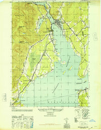
1946 Map of Northville
USGS Topo · Published 1946About this map
Northville and its surrounding river valley appear in this immediate post-war survey, documenting the landscape of the southern Adirondacks during a period of transition. The sprawling Sacandaga Reservoir dominates the eastern half of the map, created by the damming of the Sacandaga River. Along the western shores, the F J & G RR provides a critical rail link, passing through Sacandaga Park and Sweets Crossing. The map reveals the interplay between the developed village center, featuring the Central School and a Gaging Sta, and the wilder reaches of Adirondack State Park. Genealogists can locate several family burial grounds, including Gifford Valley Cem near Gifford Lake and King Cem located near the Landing Field. The shoreline is marked by distinct points such as Paradise Point and Sinclaire Point, while the interior terrain rises toward Prospect Hill.
Find a feature on this map
30 named features on this map. Tap any name to fly to it.
Don’t see what you’re looking for? This feature index may not catch every label — zoom into the map to look around manually.
Map Details
Editions of this 1946 Northville Map
This is the sole edition of this map. No revisions or reprints were ever made.
Other maps of this area

1899 · Broadalbin
USGS Topo · 1:62,500

1902 · Broadalbin
USGS Topo · 1:62,500

1903 · Gloversville
USGS Topo · 1:62,500

1907 · Lake Pleasant
USGS Topo · 1:62,500

1910 · Stony Creek
USGS Topo · 1:62,500

1943 · Gloversville
USGS Topo · 1:62,500

1945 · Edinburg
USGS Topo · 1:24,000
1945 · Galway
USGS Topo · 1:24,000

1945 · Northville
USGS Topo · 1:24,000
1945 · Jackson Summit
USGS Topo · 1:24,000