1970 Map of Northville
USGS Topo · Published 1977About this map
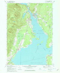
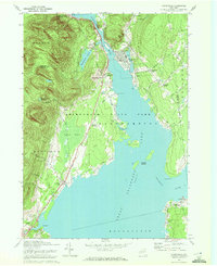
The village of Northville serves as the focal point for this survey, situated where the Sacandaga River meets the northern reaches of Great Sacandaga Lake. The landscape transition from the mountains of Adirondack State Park into the river valley is clearly visible, with the terrain marked by high points like Prospect Hill. Near the water, small communities such as Sacandaga Park and Fish House indicate a seasonal and residential economy oriented around the shoreline, including features like the Golf Course and Northampton Beach Campsite.
Find a feature on this map
52 named features on this map. Tap any name to fly to it.
Don’t see what you’re looking for? This feature index may not catch every label — zoom into the map to look around manually.
Map Details
Editions of this 1970 Northville Map
2 editions found
Other maps of this area

1899 · Broadalbin
USGS Topo · 1:62,500

1902 · Broadalbin
USGS Topo · 1:62,500

1903 · Gloversville
USGS Topo · 1:62,500

1907 · Lake Pleasant
USGS Topo · 1:62,500

1910 · Stony Creek
USGS Topo · 1:62,500

1943 · Gloversville
USGS Topo · 1:62,500

1945 · Edinburg
USGS Topo · 1:24,000

1945 · Galway
USGS Topo · 1:24,000

1945 · Northville
USGS Topo · 1:24,000
1945 · Jackson Summit
USGS Topo · 1:24,000