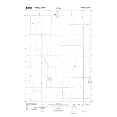
2012 Map of Northville
USGS Topo · Published 2012About this map
Northville sits at the heart of this Spink County landscape, organized along a strict grid of section lines that define the agricultural character of eastern South Dakota. The settlement is anchored by a small network of residential streets including Oak St and Elm St, with the Fairview Cem located just to the north along 382nd Ave. The surrounding terrain is marked by the winding course of Snake Cr to the southwest and the expansive Big Slough to the northeast, illustrating the drainage patterns of the James River valley.
Find a feature on this map
30 named features on this map. Tap any name to fly to it.
Don’t see what you’re looking for? This feature index may not catch every label — zoom into the map to look around manually.
Map Details
Editions of this 2012 Northville Map
This is the sole edition of this map. No revisions or reprints were ever made.
Other maps of this area

1895 · Aberdeen
USGS Topo · 1:125,000

1899 · Northville
USGS Topo · 1:125,000

1953 · Gallup
USGS Topo · 1:24,000

1953 · Warner
USGS Topo · 1:24,000

1954 · Mellette
USGS Topo · 1:24,000

1954 · Aberdeen
USGS Topo · 1:250,000

1956 · Aberdeen
USGS Topo · 1:250,000

1960 · Rudolph
USGS Topo · 1:24,000
1960 · Northville
USGS Topo · 1:24,000
1960 · Athol
USGS Topo · 1:24,000