1960 Map of Northville
USGS Topo · Published 1961About this map
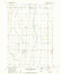
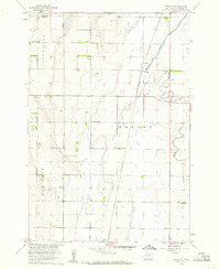
Northville serves as a central hub on this 1960s prairie landscape, situated where the Chicago and North Western railroad cuts a straight north-south line through the agricultural grid. This survey was compiled by the Geological Survey as part of the Department of the Interior program for the development of the Missouri River Basin, capturing a detailed view of Spink and Brown counties. To the west, the meandering course of Snake Creek provides a sharp contrast to the rigid section lines that define the townships of New Hope and Warner. Small agricultural settlements like Mansfield and Mellette are anchored by the rail line, reflecting the vital importance of transport to these South Dakota communities. Genealogists will find the exact placement of Fairview Cem particularly useful for tracing local family history during this era of post-war stabilization.
Find a feature on this map
11 named features on this map. Tap any name to fly to it.
Don’t see what you’re looking for? This feature index may not catch every label — zoom into the map to look around manually.
Map Details
Editions of this 1960 Northville Map
This is the sole edition of this map. No revisions or reprints were ever made.
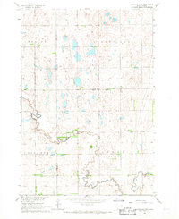
Other maps of this area

1895 · Aberdeen
USGS Topo · 1:125,000

1899 · Northville
USGS Topo · 1:125,000
1953 · Gallup
USGS Topo · 1:24,000
1953 · Warner
USGS Topo · 1:24,000
1954 · Mellette
USGS Topo · 1:24,000

1954 · Aberdeen
USGS Topo · 1:250,000

1956 · Aberdeen
USGS Topo · 1:250,000
1960 · Rudolph
USGS Topo · 1:24,000

1960 · Athol
USGS Topo · 1:24,000
1966 · Northville SW
USGS Topo · 1:24,000
Featured Places
- Mellette, Mellette Township
- Northville, Northville Township
- Mellette Township, SD
- Warner Township, SD
- Mansfield, Warner Township