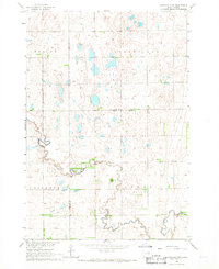
1966 Map of Northville SW
USGS Topo · Published 1967About this map
Snake Creek and its winding South Fork dominate this mid-century portrait of the South Dakota prairie, where the Faulk Co Spink Co line divides the landscape. This 1960s survey illustrates a region defined by its rural civic infrastructure and hydrology, featuring a solitary Grange Hall and a Gaging Station situated along the water's edge. The terrain is largely organized into named townships or districts such as Wesley, Northville, Pioneer, and Athol. The economy of the era is reflected in scattered resource extraction sites like the Gravel Pit and Gravel Pits found near the creek beds. This map is particularly valuable for its depiction of the natural drainage patterns and the specific placement of community landmarks before significant modern changes to the agricultural landscape.
Find a feature on this map
11 named features on this map. Tap any name to fly to it.
Don’t see what you’re looking for? This feature index may not catch every label — zoom into the map to look around manually.
Map Details
Editions of this 1966 Northville SW Map
This is the sole edition of this map. No revisions or reprints were ever made.
Other maps of this area

1899 · Northville
USGS Topo · 1:125,000

1899 · Redfield
USGS Topo · 1:125,000

1953 · Redfield North
USGS Topo · 1:24,000

1953 · Huron
USGS Topo · 1:250,000

1954 · Aberdeen
USGS Topo · 1:250,000

1954 · Huron
USGS Topo · 1:250,000

1956 · Aberdeen
USGS Topo · 1:250,000
1960 · Northville
USGS Topo · 1:24,000
1960 · Athol
USGS Topo · 1:24,000

1966 · Cresbard SE
USGS Topo · 1:24,000