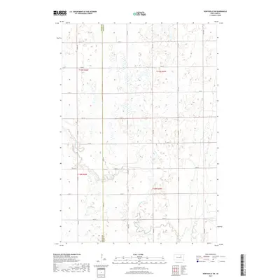
2017 Map of Northville SW
USGS Topo · Published 2017About this map
The South Fork Snake Creek meanders through this portion of the Glacial Till Plains, marking a distinct boundary where the Faulk Co Spink Co line divides the landscape. This 2017 survey reveals a strictly organized section-line road network characteristic of the Great Plains, where routes like 372nd Ave and 157th St dictate the movement across a terrain dotted with numerous seasonal wetlands and small basins. The water management and drainage patterns along the S Fork Snake Cr suggest a landscape primarily shaped by agricultural utility and glacial recession. While modern infrastructure like Co Rd 10 provides primary access, the underlying township and range system remains the dominant structural element, preserving the cadastral history of this rural South Dakota corridor.
Find a feature on this map
23 named features on this map. Tap any name to fly to it.
Don’t see what you’re looking for? This feature index may not catch every label — zoom into the map to look around manually.
Map Details
Editions of this 2017 Northville SW Map
This is the sole edition of this map. No revisions or reprints were ever made.
Other maps of this area

1899 · Northville
USGS Topo · 1:125,000

1899 · Redfield
USGS Topo · 1:125,000

1953 · Redfield North
USGS Topo · 1:24,000

1953 · Huron
USGS Topo · 1:250,000

1954 · Aberdeen
USGS Topo · 1:250,000

1954 · Huron
USGS Topo · 1:250,000

1956 · Aberdeen
USGS Topo · 1:250,000
1960 · Northville
USGS Topo · 1:24,000
1960 · Athol
USGS Topo · 1:24,000

1966 · Cresbard SE
USGS Topo · 1:24,000