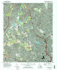
1993 Map of Northwest Atlanta
USGS Topo · Published 1995About this map
Atlanta's northwestern expanse in the early 1990s is defined by a dense intersection of river geography and urban infrastructure. The Chattahoochee River carves a winding path through the landscape, buffered by the Chattahoochee River National Recreational Area, while major industrial hubs like Inman Yard showcase the city's role as a transportation nexus. The map documents a mature urban layout featuring prominent academic and civic institutions, from the sprawling campus of the Georgia Institute of Technology and the Omni Coliseum to private schools like The Lovett Sch and Westminster Sch. Residential growth is visible across neighborhoods such as Buckhead, Vinings, and Grove Park, each punctuated by local landmarks like the Governors Mansion and the massive Lincoln Cemetery. This survey records the city just before the major transformations of the mid-90s, capturing the established rail lines, MARTA stations like West Lake Marta Sta, and the extensive park systems including Chastain Memorial Park.
Find a feature on this map
92 named features on this map. Tap any name to fly to it.
Don’t see what you’re looking for? This feature index may not catch every label — zoom into the map to look around manually.
Map Details
Editions of this 1993 Northwest Atlanta Map
This is the sole edition of this map. No revisions or reprints were ever made.
Other maps of this area

1888 · Atlanta
USGS Topo · 1:125,000

1890 · Atlanta
USGS Topo · 1:125,000

1891 · Marietta
USGS Topo · 1:125,000

1892 · Atlanta
USGS Topo · 1:125,000

1895 · Atlanta
USGS Topo · 1:125,000

1895 · Marietta
USGS Topo · 1:125,000

1897 · Marietta
USGS Topo · 1:125,000

1901 · Marietta
USGS Topo · 1:125,000

1953 · Atlanta
USGS Topo · 1:250,000

1954 · Conley
USGS Topo · 1:24,000