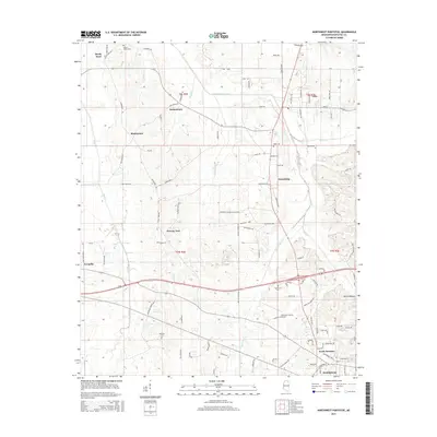
2015 Map of Northwest Pontotoc
USGS Topo · Published 2015About this map
The rolling landscape of northern Mississippi comes into focus through this 2015 study of the area northwest of Pontotoc. The terrain is defined by the winding paths of Lappatubby Creek and Tywhiskey Creek, which carve through a network of small rural settlements including Ecru, Friendship, and Possum Trot. Transportation patterns are anchored by the North Junction and the presence of the Pontotoc County Airport, illustrating how modern infrastructure has integrated with older crossroad communities like Hortontown and Buchannan. Local history is preserved in the placement of numerous family and community burial grounds, such as Shady Grove Cemetery and Weatherall Cemetery, which remain as permanent markers of the region's long-standing residential roots. The map also traces the northern reaches of the Pontotoc city limits and the industrial developments concentrated near the rail lines in Ecru.
Find a feature on this map
107 named features on this map. Tap any name to fly to it.
Don’t see what you’re looking for? This feature index may not catch every label — zoom into the map to look around manually.
Map Details
Editions of this 2015 Northwest Pontotoc Map
This is the sole edition of this map. No revisions or reprints were ever made.
Other maps of this area

1949 · New Albany
USGS Topo · 1:62,500

1951 · New Albany
USGS Topo · 1:62,500

1955 · Sherman
USGS Topo · 1:62,500

1956 · Tupelo
USGS Topo · 1:250,000

1958 · Tupelo
USGS Topo · 1:250,000

1966 · Troy NW
USGS Topo · 1:24,000

1972 · Randolph
USGS Topo · 1:24,000
1972 · Southwest Pontotoc
USGS Topo · 1:24,000

1980 · Northwest Pontotoc
USGS Topo · 1:24,000
1980 · Thaxton
USGS Topo · 1:24,000