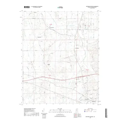
2018 Map of Northwest Pontotoc
USGS Topo · Published 2018About this map
Ecru and the northern outskirts of Pontotoc anchor this landscape, where the local economy and settlement patterns are defined by a network of drainage creeks and rural roads. The northern portion of the map is marked by the winding course of Lappatubby Creek and the small communities of Hortontown and Buchannan. The rural character of Pontotoc County is evident in the numerous family-named landmarks and cemeteries, such as Shady Grove Cem and Weatherall Cem. A distinct transition occurs in the south, where the Pontotoc County Airport and the modern road networks of North Junction signal the area's development. Small clusters of homes and churches at Friendship and Possum Trot provide evidence of long-standing local community centers that have persisted through the years.
Find a feature on this map
91 named features on this map. Tap any name to fly to it.
Don’t see what you’re looking for? This feature index may not catch every label — zoom into the map to look around manually.
Map Details
Editions of this 2018 Northwest Pontotoc Map
This is the sole edition of this map. No revisions or reprints were ever made.
Other maps of this area

1949 · New Albany
USGS Topo · 1:62,500

1951 · New Albany
USGS Topo · 1:62,500

1955 · Sherman
USGS Topo · 1:62,500

1956 · Tupelo
USGS Topo · 1:250,000

1958 · Tupelo
USGS Topo · 1:250,000

1966 · Troy NW
USGS Topo · 1:24,000

1972 · Randolph
USGS Topo · 1:24,000
1972 · Southwest Pontotoc
USGS Topo · 1:24,000

1980 · Northwest Pontotoc
USGS Topo · 1:24,000
1980 · Thaxton
USGS Topo · 1:24,000