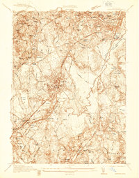
1936 Map of Norwood
USGS Topo · Published 1936About this map
The Neponset River corridor defines the industrial and natural geography of Norfolk County in the mid-1930s, winding through extensive marshlands like Fowl Meadow and the Neponset River Reservation. This survey captures the complex rail infrastructure of the New York New Haven and Hartford railroad, which supported bustling centers at Norwood and Dedham. Beyond the main village grids, the landscape is dotted with specialized institutions and landmarks, including the Norfolk County Agricultural Sch and the Sharon Sanatorium. Local industry is evidenced by water-powered sites such as Trowel Shop Pond and Saw Mill Pd. Cultural and recreational life is visible through the numerous country clubs and the distinctively named Satans Kingdom terrain. The map provides a detailed view of residential expansion in areas like Readville Manor and Walpole Heights just before the mid-century suburban boom.
Find a feature on this map
98 named features on this map. Tap any name to fly to it.
Don’t see what you’re looking for? This feature index may not catch every label — zoom into the map to look around manually.
Map Details
Editions of this 1936 Norwood Map
This is the sole edition of this map. No revisions or reprints were ever made.
Other maps of this area

1886 · Dedham
USGS Topo · 1:62,500

1886 · Framingham
USGS Topo · 1:62,500

1887 · Franklin
USGS Topo · 1:62,500

1889 · Franklin
USGS Topo · 1:62,500

1889 · Framingham
USGS Topo · 1:62,500

1893 · Franklin
USGS Topo · 1:62,500

1893 · Boston
USGS Topo · 1:62,500

1894 · Dedham
USGS Topo · 1:62,500

1894 · Framingham
USGS Topo · 1:62,500

1903 · Boston
USGS Topo · 1:62,500