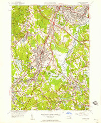
1946 Map of Norwood
USGS Topo · Published 1958About this map
The Neponset River corridor defines the industrial and geographic character of this mid-century landscape, winding through Fowl Meadow and connecting several historic mill and rail centers. The presence of the New York New Haven and Hartford railroad lines anchors the development of hubs like Canton Junction, East Walpole, and Readville. The map captures a period of transition, where major infrastructure like the Circumferential Highway and Norwood Airfield appears alongside established local institutions such as the Norfolk County Agricultural School and the Sharon Sanatorium. From the heights of Moose Hill to the wetlands of the Blue Hills Reservation, the map meticulously documents the intersection of expanding transportation networks with the area's numerous ponds and local landmarks, including the Knollwood Cemetery and Satans Kingdom.
Find a feature on this map
90 named features on this map. Tap any name to fly to it.
Don’t see what you’re looking for? This feature index may not catch every label — zoom into the map to look around manually.
Map Details
Editions of this 1946 Norwood Map
This is the sole edition of this map. No revisions or reprints were ever made.
Other maps of this area

1886 · Dedham
USGS Topo · 1:62,500

1886 · Framingham
USGS Topo · 1:62,500

1887 · Franklin
USGS Topo · 1:62,500

1889 · Franklin
USGS Topo · 1:62,500

1889 · Framingham
USGS Topo · 1:62,500

1893 · Franklin
USGS Topo · 1:62,500

1893 · Boston
USGS Topo · 1:62,500

1894 · Dedham
USGS Topo · 1:62,500

1894 · Framingham
USGS Topo · 1:62,500

1903 · Boston
USGS Topo · 1:62,500