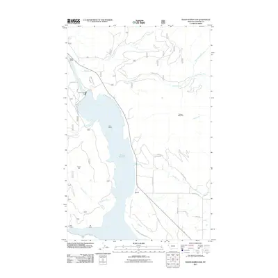
2011 Map of Noxon Rapids Dam
USGS Topo · Published 2011About this map
The Noxon Reservoir dominates this section of Sanders County, created by the massive Noxon Rapids Dam on the Clark Fork. The settlement of Tuscor sits along the eastern shore, positioned near the intersection of Old Hwy and the local rail infrastructure. This 2011 survey details the complex network of forest and access roads, such as McKay Creek Rd and Swamp Creek Rd, which penetrate the steep elevations of Green Mountain and Tuscor Hill. The landscape is defined by deep drainages and gulches, including Miller Gulch, Burr Gulch, and Iff Gulch, illustrating the rugged topography that surrounds the reservoir. For researchers, the map provides a clear view of the modern shoreline, including features like Rock Island and the various forks of McKay Creek feeding into the basin.
Find a feature on this map
31 named features on this map. Tap any name to fly to it.
Don’t see what you’re looking for? This feature index may not catch every label — zoom into the map to look around manually.
Map Details
Editions of this 2011 Noxon Rapids Dam Map
This is the sole edition of this map. No revisions or reprints were ever made.
Other maps of this area

1920 · Libby
USGS Topo · 1:125,000

1930 · Libby
USGS Topo · 1:125,000

1932 · Libby
USGS Topo · 1:125,000

1932 · Trout Creek
USGS Topo · 1:125,000

1935 · Trout Creek
USGS Topo · 1:125,000

1936 · Trout Creek
USGS Topo · 1:125,000

1956 · Wallace
USGS Topo · 1:250,000

1957 · Kalispell
USGS Topo · 1:250,000

1960 · Kalispell
USGS Topo · 1:250,000

1960 · Wallace
USGS Topo · 1:250,000