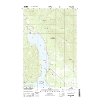
2017 Map of Noxon Rapids Dam
USGS Topo · Published 2017About this map
Noxon Reservoir dominates this portion of the Clark Fork river valley within the Kaniksu National Forest. The landscape is defined by the hydraulic engineering of the Noxon Rapids Dam, which transformed the river into a wide reservoir, punctuated by features like Rock Island and the sheltered Marten Creek Bay. The small settlement of Tuscor sits along the eastern shore, positioned between the water and the rising slopes of Tuscor Hill. To the east, the terrain ascends sharply toward Green Mtn, dissected by numerous drainages including Rock Cr, Engle Cr, and Swamp Cr. A network of Forest Service roads, such as Stevens Creek Rd and McKay Creek Rd, provides access to the timbered highlands and tributary valleys that characterize this section of Sanders County.
Find a feature on this map
44 named features on this map. Tap any name to fly to it.
Don’t see what you’re looking for? This feature index may not catch every label — zoom into the map to look around manually.
Map Details
Editions of this 2017 Noxon Rapids Dam Map
This is the sole edition of this map. No revisions or reprints were ever made.
Other maps of this area

1920 · Libby
USGS Topo · 1:125,000

1930 · Libby
USGS Topo · 1:125,000

1932 · Libby
USGS Topo · 1:125,000

1932 · Trout Creek
USGS Topo · 1:125,000

1935 · Trout Creek
USGS Topo · 1:125,000

1936 · Trout Creek
USGS Topo · 1:125,000

1956 · Wallace
USGS Topo · 1:250,000

1957 · Kalispell
USGS Topo · 1:250,000

1960 · Kalispell
USGS Topo · 1:250,000

1960 · Wallace
USGS Topo · 1:250,000