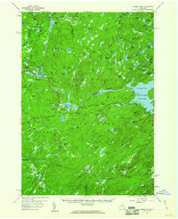
1957 Map of Number Four
USGS Topo · Published 1964About this map
Adirondack State Park dominates this mid-century survey of Lewis and Herkimer counties, where the vast water resources of the western Adirondacks are carefully documented. The map centers on the high-elevation Stillwater Reservoir, showing its normal pool elevation and surrounding wilderness. This area is defined by its complex network of interconnected ponds and lakes, from the northern Lanes Pond and Trout Pond down to Huckleberry Lake in the south. The small settlement of Number Four serves as a local hub near Woodwardia Pond, connected by the Number Four Road and Stillwater Road. The hydro-industrial character of the landscape is evident at Eagle Falls and Moshier Falls, where spillway elevations and reservoirs indicate the managed flow of the Beaver River. For those interested in forest history, the survey identifies several fire observation points, including a Lookout Tower near the center of the sheet and another on Lookout Mtn overlooking the reservoir.
Find a feature on this map
102 named features on this map. Tap any name to fly to it.
Don’t see what you’re looking for? This feature index may not catch every label — zoom into the map to look around manually.
Map Details
Editions of this 1957 Number Four Map
4 editions found
Other maps of this area

1901 · Old Forge
USGS Topo · 1:62,500

1903 · Big Moose
USGS Topo · 1:62,500

1905 · Port Leyden
USGS Topo · 1:62,500

1907 · Port Leyden
USGS Topo · 1:62,500

1911 · Lowville
USGS Topo · 1:62,500

1912 · Number Four
USGS Topo · 1:62,500

1912 · Mc Keever
USGS Topo · 1:62,500

1913 · Lowville
USGS Topo · 1:62,500

1913 · Lake Bonaparte
USGS Topo · 1:62,500

1915 · Number Four
USGS Topo · 1:62,500