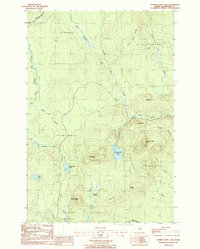
1986 Map of Number Nine Lake
USGS Topo · Published 1987About this map
Number Nine Mtn and Saddleback Mtn anchor this mid-1980s topographic survey of a remote interior section of Aroostook County. This landscape is defined by the headwaters of the Presque Isle Stream and its various branches, including the West Branch Presque Isle Stream and East Branch Presque Isle Stream. The presence of Mahan Camp and Finnemore Camp, alongside a network of private roads, indicates a region primarily dedicated to timber management and seasonal sporting use. Significant water bodies like Number Nine Lake and Presque Isle Lake are connected by small brooks and drainage ways such as Number Nine Stream. In the southern portion, the terrain shifts toward Hovey Swamp and the upper reaches of the South Branch Meduxnekeag River, illustrating the complex hydrological divide of this upland Maine territory.
Find a feature on this map
35 named features on this map. Tap any name to fly to it.
Don’t see what you’re looking for? This feature index may not catch every label — zoom into the map to look around manually.
Map Details
Editions of this 1986 Number Nine Lake Map
This is the sole edition of this map. No revisions or reprints were ever made.
Other maps of this area

1934 · Bridgewater
USGS Topo · 1:48,000

1935 · Howe Brook
USGS Topo · 1:48,000

1935 · Presque Isle
USGS Topo · 1:62,500

1936 · Mars Hill
USGS Topo · 1:48,000

1938 · Bridgewater
USGS Topo · 1:62,500

1939 · Howe Brook
USGS Topo · 1:62,500

1940 · Mars Hill
USGS Topo · 1:62,500

1951 · Mars Hill
USGS Topo · 1:62,500

1951 · Bridgewater
USGS Topo · 1:62,500

1953 · Bridgewater
USGS Topo · 1:50,000