
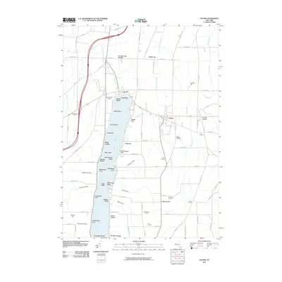
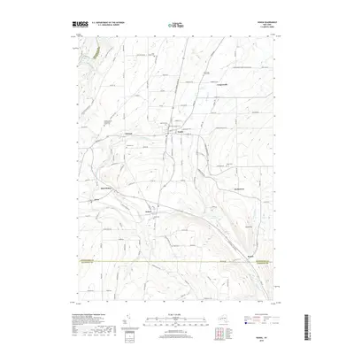
1943 Map of Nunda
USGS Topo · Published 1960About this map
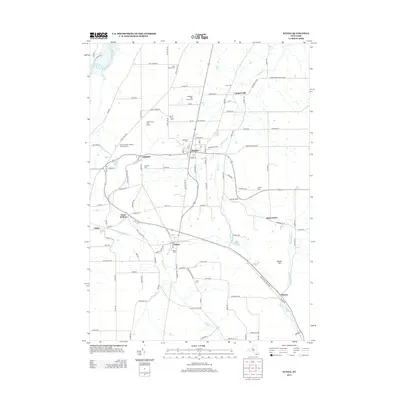
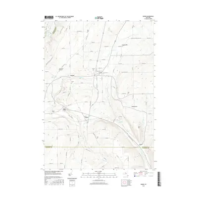
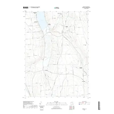
Keshequa Creek carves a deep valley through this mid-century landscape, where the agricultural flats around Nunda meet the rising wooded hills of Letchworth Park. The map documents a critical rail corridor during the war years, showing the parallel routes of the Pennsylvania and Erie railroads as they navigate the difficult topography south of Nunda Junction. In the western portion of the sheet, the Genesee River flows through the gorge near Oakland, while the eastern side is dominated by the prominent elevation of Round Top. Small rural clusters like Barkertown and Hunt Hollow appear as they were in the early 1940s, providing a look at local settlement patterns before post-war changes. The detailed survey captures the road networks connecting Dalton and Coopersville, reflecting a period when rail and river valleys still dictated the primary movement of goods and people through Livingston County.
Find a feature on this map
27 named features on this map. Tap any name to fly to it.
Don’t see what you’re looking for? This feature index may not catch every label — zoom into the map to look around manually.
Map Details
Editions of this 1943 Nunda Map
This is the sole edition of this map. No revisions or reprints were ever made.
Historical Maps of Mount Morris Through Time
81 maps found

1902 Wayland
Livingston County, NY

1904 Caledonia
Livingston County, NY

1904 Wayland
Livingston County, NY

1905 Nunda
Livingston County, NY

1934 Rush
Livingston County, NY

1942 Conesus
Livingston County, NY

1942 Livonia
Livingston County, NY

1943 Mount Morris
Livingston County, NY
1943 Nunda
Livingston County, NY

1943 Ossian
Livingston County, NY

1943 Sonyea
Livingston County, NY

1944 Geneseo
Livingston County, NY

1944 Leicester
Livingston County, NY

1944 Mount Morris
Livingston County, NY

1944 Nunda
Livingston County, NY

1944 Ossian
Livingston County, NY

1944 Sonyea
Livingston County, NY

1950 Caledonia
Livingston County, NY

1950 Geneseo
Livingston County, NY

1951 Caledonia
Livingston County, NY

1951 Leicester
Livingston County, NY

1951 Livonia
Livingston County, NY

1951 Rush
Livingston County, NY

1957 Conesus
Livingston County, NY

1964 Conesus
Livingston County, NY

1971 Rush
Livingston County, NY

1972 Mount Morris
Livingston County, NY

1972 Nunda
Livingston County, NY

1972 Ossian
Livingston County, NY

1972 Sonyea
Livingston County, NY

1983 Canandaigua
Livingston County, NY

2010 Caledonia
Livingston County, NY

2010 Conesus
Livingston County, NY

2010 Geneseo
Livingston County, NY

2010 Leicester
Livingston County, NY
2010 Livonia
Livingston County, NY

2010 Mount Morris
Livingston County, NY
2010 Nunda
Livingston County, NY

2010 Ossian
Livingston County, NY

2010 Rush
Livingston County, NY

2010 Sonyea
Livingston County, NY

2013 Caledonia
Livingston County, NY
2013 Conesus
Livingston County, NY

2013 Geneseo
Livingston County, NY

2013 Leicester
Livingston County, NY
2013 Livonia
Livingston County, NY

2013 Mount Morris
Livingston County, NY
2013 Nunda
Livingston County, NY

2013 Ossian
Livingston County, NY

2013 Rush
Livingston County, NY

2013 Sonyea
Livingston County, NY

2016 Caledonia
Livingston County, NY
2016 Conesus
Livingston County, NY

2016 Geneseo
Livingston County, NY
2016 Leicester
Livingston County, NY
2016 Livonia
Livingston County, NY

2016 Mount Morris
Livingston County, NY
2016 Nunda
Livingston County, NY
2016 Ossian
Livingston County, NY
2016 Rush
Livingston County, NY

2016 Sonyea
Livingston County, NY
2019 Caledonia
Livingston County, NY
2019 Conesus
Livingston County, NY
2019 Geneseo
Livingston County, NY
2019 Leicester
Livingston County, NY
2019 Livonia
Livingston County, NY

2019 Mount Morris
Livingston County, NY
2019 Nunda
Livingston County, NY
2019 Ossian
Livingston County, NY
2019 Rush
Livingston County, NY

2019 Sonyea
Livingston County, NY

2023 Caledonia
Livingston County, NY

2023 Conesus
Livingston County, NY

2023 Geneseo
Livingston County, NY

2023 Leicester
Livingston County, NY

2023 Livonia
Livingston County, NY

2023 Mount Morris
Livingston County, NY

2023 Nunda
Livingston County, NY

2023 Ossian
Livingston County, NY

2023 Rush
Livingston County, NY

2023 Sonyea
Livingston County, NY