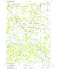
1972 Map of Nunica
USGS Topo · Published 1975About this map
The Grand River carves a broad valley through this portion of Ottawa County, creating a landscape defined by expansive wetlands and low-lying bayous. The settlement of Nunica sits at a strategic junction north of the river, where the Grand Trunk Western railroad passes through Crockery township. This 1970s landscape reveals an economy shifting between traditional riverfront activity and mid-century transit, marked by the numerous sandpits and gravel pits that flank the waterways and roads.
Find a feature on this map
48 named features on this map. Tap any name to fly to it.
Don’t see what you’re looking for? This feature index may not catch every label — zoom into the map to look around manually.
Map Details
Editions of this 1972 Nunica Map
This is the sole edition of this map. No revisions or reprints were ever made.
Other maps of this area

1929 · Holland
USGS Topo · 1:62,500

1930 · Muskegon
USGS Topo · 1:62,500

1932 · Holland
USGS Topo · 1:62,500

1936 · Muskegon
USGS Topo · 1:62,500

1945 · Ravenna
USGS Topo · 1:62,500

1954 · Milwaukee
USGS Topo · 1:250,000

1954 · Midland
USGS Topo · 1:250,000

1958 · Midland
USGS Topo · 1:250,000

1958 · Milwaukee
USGS Topo · 1:250,000

1958 · Allendale
USGS Topo · 1:24,000