
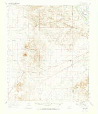
1961 Map of Nutt
USGS Topo · Published 1964About this map
The Atchison Topeka and Santa Fe railroad corridor defines this high-desert landscape in the early 1960s, cutting through the junction of Sierra, Dona Ana, and Luna counties. The small settlement of Nutt serves as a focal point near Nutt Mountain, surrounded by a network of isolated homesteads and ranching outposts such as Duncan Ranch, Jones Ranch, and Winder Ranch. This era shows the transition of local infrastructure, documented by the Hatch Airport (Aband) and a series of deep desert arroyos including Arroyo Cuervo and Arroyo Jaralosa that drain toward the Rio Grande in the northeast. Genealogists and local historians can locate specific landmarks like the North Cem and La Capilla de Don Silverio, which reflect the cultural footprint of families settled among the canyons of the Sierra de las Uvas.
Find a feature on this map
32 named features on this map. Tap any name to fly to it.
Don’t see what you’re looking for? This feature index may not catch every label — zoom into the map to look around manually.
Map Details
Editions of this 1961 Nutt Map
2 editions found
Other maps of this area

1899 · Deming
USGS Topo · 1:125,000

1915 · Deming
USGS Topo · 1:125,000

1935 · Hillsboro
USGS Topo · 1:48,000

1940 · Hillsboro
USGS Topo · 1:62,500

1943 · Corralitos Ranch
USGS Topo · 1:62,500

1955 · Las Cruces
USGS Topo · 1:250,000

1958 · Las Cruces
USGS Topo · 1:250,000

1958 · Arroyo Cuervo
USGS Topo · 1:24,000

1959 · Hatch
USGS Topo · 1:24,000
1959 · Souse Springs
USGS Topo · 1:24,000