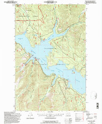
1994 Map of Nyack SW
USGS Topo · Published 1997About this map
Hungry Horse Reservoir dominates this high-country landscape, its waters filling the deep canyons of the Flathead River and creating numerous inlets like Emery Bay and Abbot Bay. The reservoir is a defining feature of the Flathead National Forest, reflecting the mid-20th-century hydrological management of the region. The map details a network of lookouts and observation sites, including the Firefighter Mtn Lookout and Wounded Buck Observation Point, which were vital for monitoring the surrounding timberlands.
Find a feature on this map
41 named features on this map. Tap any name to fly to it.
Don’t see what you’re looking for? This feature index may not catch every label — zoom into the map to look around manually.
Map Details
Editions of this 1994 Nyack SW Map
This is the sole edition of this map. No revisions or reprints were ever made.
Other maps of this area

1914 · Nyack
USGS Topo · 1:125,000

1943 · Kalispell
USGS Topo · 1:125,000

1957 · Kalispell
USGS Topo · 1:250,000

1960 · Kalispell
USGS Topo · 1:250,000

1960 · Cut Bank
USGS Topo · 1:250,000

1961 · Kalispell
USGS Topo · 1:250,000

1962 · Doris Mountain
USGS Topo · 1:24,000

1962 · Hungry Horse
USGS Topo · 1:24,000

1962 · Hash Mountain
USGS Topo · 1:24,000

1963 · Cut Bank
USGS Topo · 1:250,000