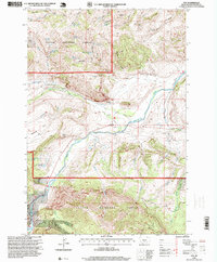
1996 Map of Nye
USGS Topo · Published 1999About this map
Stillwater River drainage dominates this late twentieth-century survey, where the waterway flows through the rugged transition from high mountain forest to valley flats. The settlement of Nye serves as a focal point near the confluence of the West Fork Stillwater River, featuring local infrastructure such as a Substa, a Gaging Sta, and a Cem. The landscape is sharply defined by the boundaries of the Custer National Forest, which covers the southern and western portions of the quadrangle with dense contours and numerous springs like Ekwortzel Spring and Custer Spring. To the west, Horseman Flats and the uniquely named Buffalo Jump suggest a long history of land use. Evidence of the local economy appears in Robinson and scattered Gravel Pits, while numerous Corrals and 4WD tracks indicate the area's continued reliance on ranching and backcountry access.
Find a feature on this map
30 named features on this map. Tap any name to fly to it.
Don’t see what you’re looking for? This feature index may not catch every label — zoom into the map to look around manually.
Map Details
Editions of this 1996 Nye Map
This is the sole edition of this map. No revisions or reprints were ever made.
Other maps of this area

1891 · Big Timber
USGS Topo · 1:125,000

1893 · Big Timber
USGS Topo · 1:125,000

1898 · Granite Mountain District
USGS Topo · 1:125,000

1932 · Nye No 1
USGS Topo · 1:48,000

1932 · Nye No 2
USGS Topo · 1:48,000

1939 · Mt Wood
USGS Topo · 1:62,500

1941 · Mt. Wood
USGS Topo · 1:62,500
1954 · Sliderock Mountain
USGS Topo · 1:24,000

1954 · Billings
USGS Topo · 1:250,000
1955 · Wildcat Draw
USGS Topo · 1:24,000