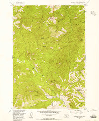
1954 Map of Sliderock Mountain
USGS Topo · Published 1956About this map
Iron Mountain Mine and the Silver King Mine anchor a landscape defined by mid-century extraction and wilderness management. Situated along the boundary of Sweet Grass and Stillwater Counties, this territory was meticulously mapped by the Tennessee Valley Authority for the Missouri River Basin development program. The map documents an intricate network of narrow gulches, such as Placer Gulch and Fire Gulch, which served as the primary conduits for early prospecting. The presence of Wepler Cabin and various jeep trails and pack trails indicates the remote nature of human habitation and travel during this era. High peaks like Sliderock Mountain and Ellis Mountain dominate the terrain, which transitions from the Gallatin National Forest to the Custer National Forest, illustrating the vast reach of federal forest reserves in south-central Montana.
Find a feature on this map
42 named features on this map. Tap any name to fly to it.
Don’t see what you’re looking for? This feature index may not catch every label — zoom into the map to look around manually.
Map Details
Editions of this 1954 Sliderock Mountain Map
3 editions found
Other maps of this area

1891 · Livingston
USGS Topo · 1:250,000

1891 · Big Timber
USGS Topo · 1:125,000

1893 · Livingston
USGS Topo · 1:250,000

1893 · Big Timber
USGS Topo · 1:125,000

1898 · Granite Mountain District
USGS Topo · 1:125,000

1932 · Nye No 2
USGS Topo · 1:48,000

1939 · Mt Wood
USGS Topo · 1:62,500

1941 · Mt. Wood
USGS Topo · 1:62,500

1941 · Mt Douglas
USGS Topo · 1:62,500

1943 · Mt Douglas
USGS Topo · 1:62,500