
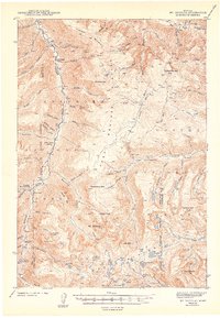
1943 Map of Mt Douglas
USGS Topo · Published 1943About this map
Boulder Plateau dominates this high-altitude landscape, where the headwaters of the Boulder River and Stillwater River carve deep drainages through some of Montana's most challenging high-country terrain. Surveyed in the years leading into the early 1940s, the map reveals a remote region where human presence is defined by scattered outposts like Clydehurst Ranch and Hells Canyon Ranch rather than established towns. The area is a mosaic of public lands, divided between the Absaroka National Forest and Custer National Forest, with administrative control points such as the Fourmile Guard Station and Box Canyon Guard Station situated along the mountain flanks. High peaks including Snowy Peak, Chrome Mtn, and the namesake Mt Douglas punctuate the skyline. Notable for its colorful nomenclature, the map identifies landmarks like Froze-to-Death Creek and Breakneck Mtn, reflecting the harsh conditions encountered by early explorers and surveyors.
Find a feature on this map
71 named features on this map. Tap any name to fly to it.
Don’t see what you’re looking for? This feature index may not catch every label — zoom into the map to look around manually.
Map Details
Editions of this 1943 Mt Douglas Map
2 editions found
Other maps of this area

1891 · Livingston
USGS Topo · 1:250,000

1891 · Big Timber
USGS Topo · 1:125,000

1893 · Livingston
USGS Topo · 1:250,000

1893 · Big Timber
USGS Topo · 1:125,000

1898 · Granite Mountain District
USGS Topo · 1:125,000

1932 · Nye No 2
USGS Topo · 1:48,000

1939 · Mt Wood
USGS Topo · 1:62,500

1940 · Mt. Cowen
USGS Topo · 1:62,500

1940 · Mt Wallace
USGS Topo · 1:62,500

1941 · Mt. Wood
USGS Topo · 1:62,500