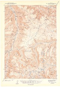
1943 Map of Mt. Douglas
USGS Topo · Published 1943About this map
The Boulder River carves through the high terrain of the Absaroka National Forest, where this survey records a landscape shaped by early 20th-century ranching and mineral exploration. Several family-named properties like Clydehurst Ranch, Hells Canyon Ranch, and Lazy Day Ranch are established along the river valley, while the Gish Mine marks industrial interest in the northern slopes. The map details a network of high-altitude drainages, from the curiously named Froze-to-Death Creek to Upsidedown Creek, all flowing beneath prominent peaks such as Mt Douglas and Breakneck Mtn. Administrative presence is noted by the Fourmile Guard Station and Box Canyon Guard Station, indicating the active management of these wild lands by the Forest Service just after the turn of the decade. Dozens of alpine water bodies, including Mirror Lake and the Rainbow Lakes, are documented among the basins of the Boulder Plateau.
Find a feature on this map
79 named features on this map. Tap any name to fly to it.
Don’t see what you’re looking for? This feature index may not catch every label — zoom into the map to look around manually.
Map Details
Editions of this 1943 Mt. Douglas Map
2 editions found

Other maps of this area

1891 · Livingston
USGS Topo · 1:250,000

1891 · Big Timber
USGS Topo · 1:125,000

1893 · Livingston
USGS Topo · 1:250,000

1893 · Big Timber
USGS Topo · 1:125,000

1898 · Granite Mountain District
USGS Topo · 1:125,000

1932 · Nye No 2
USGS Topo · 1:48,000

1939 · Mt Wood
USGS Topo · 1:62,500

1940 · Mt. Cowen
USGS Topo · 1:62,500

1940 · Mt Wallace
USGS Topo · 1:62,500

1941 · Mt. Wood
USGS Topo · 1:62,500