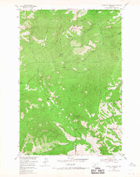
1954 Map of Sliderock Mountain
USGS Topo · Published 1968About this map
The high peaks of the Gallatin National Forest and Custer National Forest dominate this mid-century survey of the Sweet Grass region. The landscape is defined by its mining heritage, with several prospects clustered around Gold Hill, including the Gold Hill Mine, Surprise Mine, and Silver King Mine. These sites sit at the head of Placer Gulch and Fire Gulch, suggesting the area's mineral-driven economy during the earlier half of the century. Evidence of local habitation and movement is visible at the Wepler Cabin and along the Lodgepole Trail. The drainage patterns of West Bridger Creek and Upper Deer Creek illustrate the complex watershed of these mountains, while high points like Sliderock Mountain and Sugarloaf Mountain serve as primary topographical anchors.
Find a feature on this map
39 named features on this map. Tap any name to fly to it.
Don’t see what you’re looking for? This feature index may not catch every label — zoom into the map to look around manually.
Map Details
Editions of this 1954 Sliderock Mountain Map
3 editions found
Other maps of this area

1891 · Livingston
USGS Topo · 1:250,000

1891 · Big Timber
USGS Topo · 1:125,000

1893 · Livingston
USGS Topo · 1:250,000

1893 · Big Timber
USGS Topo · 1:125,000

1898 · Granite Mountain District
USGS Topo · 1:125,000

1932 · Nye No 2
USGS Topo · 1:48,000

1939 · Mt Wood
USGS Topo · 1:62,500

1941 · Mt. Wood
USGS Topo · 1:62,500

1941 · Mt Douglas
USGS Topo · 1:62,500

1943 · Mt Douglas
USGS Topo · 1:62,500