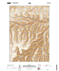
2020 Map of Nye
USGS Topo · Published 2020About this map
Whittaker Flats and the surrounding drainage network of the Blue Mountains foothills define this portion of Umatilla County. The landscape is characterized by a series of deep canyons and seasonal water sources, which likely supported early ranching and homesteading efforts. The naming of Schoolhouse Canyon and Windmill Canyon points to former focal points of rural life and early water management. Transport across this terrain relies on established routes like Stock Drive Rd and Bear Creek Rd, which navigate the elevation changes between the canyon floors and the plateaus. Notable water features include a series of distinct springs such as Lower Rugg Spring, Middle Rugg Spring, and Upper Rugg Spring, while drainage is primarily handled by W Birch Cr and Bear Cr.
Find a feature on this map
29 named features on this map. Tap any name to fly to it.
Don’t see what you’re looking for? This feature index may not catch every label — zoom into the map to look around manually.
Map Details
Editions of this 2020 Nye Map
This is the sole edition of this map. No revisions or reprints were ever made.
Other maps of this area

1908 · Umatilla
USGS Topo · 1:125,000

1935 · Pendleton
USGS Topo · 1:125,000

1953 · Pendleton
USGS Topo · 1:250,000

1956 · Pendleton
USGS Topo · 1:250,000

1966 · Mc Kay Reservoir
USGS Topo · 1:24,000
1966 · Coombs Canyon
USGS Topo · 1:24,000

1967 · Nye
USGS Topo · 1:24,000

1967 · Granite Meadows
USGS Topo · 1:24,000

1967 · Carney Butte
USGS Topo · 1:24,000

1967 · Pilot Rock
USGS Topo · 1:24,000