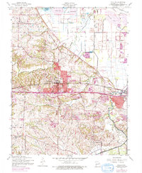
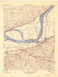
1954 Map of O'Fallon
USGS Topo · Published 1975About this map
O'Fallon and St Peters anchor this 1954 landscape, which preserves the mid-century transition of St. Charles County as urban expansion began to ripple westward. The corridor of the Norfolk and Western railroad and the newly appearing Interstate 70 trace the path of rapid development, yet the map remains deeply rooted in its rural origins. Significant local history is represented by the St Marys College campus and the grounds of Fort Zumwalt State Park. To the north, the terrain flattens into the floodplain of Peruque Creek, where numerous levee systems protect agricultural tracts and bodies of water like Lharky Lake and Pallardy Lake. Genealogists will find interest in several established sites including Assumption Cem, Mount Zion Cem, and the Dardenne Ch, which served the scattered farming communities across the Dardenne and Cuivre districts.
Find a feature on this map
26 named features on this map. Tap any name to fly to it.
Don’t see what you’re looking for? This feature index may not catch every label — zoom into the map to look around manually.
Map Details
Editions of this 1954 O'Fallon Map
4 editions found
Other maps of this area

1903 · O'Fallon
USGS Topo · 1:125,000

1931 · Brussels
USGS Topo · 1:62,500

1932 · Manchester NE
USGS Topo · 1:24,000

1937 · Weldon Spring
USGS Topo · 1:24,000

1939 · Brussels
USGS Topo · 1:62,500

1940 · Weldon Spring
USGS Topo · 1:24,000

1941 · Troy
USGS Topo · 1:62,500

1943 · Brussels
USGS Topo · 1:62,500

1945 · Troy
USGS Topo · 1:62,500
1947 · Chesterfield
USGS Topo · 1:24,000