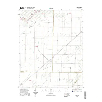
2017 Map of O'Kean
USGS Topo · Published 2017About this map
O'Kean serves as the central hub of this agricultural landscape in northeastern Arkansas, situated where the lowlands meet a complex system of drainage and irrigation. The terrain is defined by the winding course of the Black River in the northwest and the Cache River to the southeast, with a dense network of man-made channels such as Lateral Number 10 and Beaver Dam Ditch facilitating the region's farming economy. Small settlements like Sharum and High Point are scattered along the grid, often anchored by local heritage sites such as Sharum Cem and Liberty Cem. The map reveals a land heavily engineered for water management, evident in the numerous laterals and ditches like Post Oak Ditch and Conley Ditch that crisscross the county lines between Randolph, Greene, and Lawrence. This 2017 survey reflects the persistent rural character of the Delta, where historic cemeteries like Ford Cem and Serge Cem remain as physical connections to early family farmsteads.
Find a feature on this map
77 named features on this map. Tap any name to fly to it.
Don’t see what you’re looking for? This feature index may not catch every label — zoom into the map to look around manually.
Map Details
Editions of this 2017 O'Kean Map
This is the sole edition of this map. No revisions or reprints were ever made.
Other maps of this area

1932 · Walnut Ridge
USGS Topo · 1:62,500

1935 · Knobel
USGS Topo · 1:62,500

1935 · Reyno
USGS Topo · 1:62,500

1935 · Walnut Ridge
USGS Topo · 1:62,500

1940 · Gainesville
USGS Topo · 1:62,500

1941 · Knobel
USGS Topo · 1:62,500

1957 · Poplar Bluff
USGS Topo · 1:250,000

1958 · Gainesville
USGS Topo · 1:62,500

1959 · Poplar Bluff
USGS Topo · 1:250,000
1960 · Gainesville
USGS Topo · 1:62,500