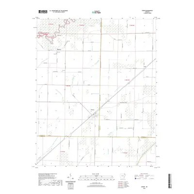
2020 Map of O'Kean
USGS Topo · Published 2020About this map
O'Kean serves as the central hub of this northeastern Arkansas landscape, situated where the borders of Randolph, Greene, and Lawrence counties converge. The terrain is defined by an intricate network of drainage systems, including Grassy Slough, Beaver Dam Ditch, and numerous numbered laterals like Lateral Number 10, all flowing toward the Cache River. This 2020 survey reveals a rural area deeply connected to its land, with small settlements such as Sharum and Case linked by a grid of county roads and HWY 304 E. Genealogists will find a high concentration of small burial grounds scattered across the townships, including Sharum Cem, Liberty Cem, and Ford Cem. The presence of these family-named sites alongside landmarks like High Point and Tupelo Slough reflects a long-established agricultural community maintaining its roots amidst the managed wetlands and irrigation ditches of the Mississippi Alluvial Plain.
Find a feature on this map
76 named features on this map. Tap any name to fly to it.
Don’t see what you’re looking for? This feature index may not catch every label — zoom into the map to look around manually.
Map Details
Editions of this 2020 O'Kean Map
This is the sole edition of this map. No revisions or reprints were ever made.
Other maps of this area

1932 · Walnut Ridge
USGS Topo · 1:62,500

1935 · Knobel
USGS Topo · 1:62,500

1935 · Reyno
USGS Topo · 1:62,500

1935 · Walnut Ridge
USGS Topo · 1:62,500

1940 · Gainesville
USGS Topo · 1:62,500

1941 · Knobel
USGS Topo · 1:62,500

1957 · Poplar Bluff
USGS Topo · 1:250,000

1958 · Gainesville
USGS Topo · 1:62,500

1959 · Poplar Bluff
USGS Topo · 1:250,000
1960 · Gainesville
USGS Topo · 1:62,500