
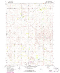
1964 Map of O'Neill SW
USGS Topo · Published 1965About this map
The South Fork Elkhorn River meanders across the southern portion of this mid-1960s landscape, providing a critical drainage point for the surrounding Nebraska ranchland. This quadrangle captures the rural transitions between several local townships, including Gratton, Shamrock, Inman, Chambers, and Mcclure. The terrain is characterized by the presence of Dry Creek and a complex network of field lines and fence boundaries, which illustrate the agricultural divisions of the era. A lone Gravel Pit near the river suggests small-scale industrial activity or road maintenance supporting the local transport network. The map detail highlights the sparse settlement pattern typical of the Sandhills region, where topography and water access dictated the placement of homesteads and grazing lands.
Find a feature on this map
9 named features on this map. Tap any name to fly to it.
Don’t see what you’re looking for? This feature index may not catch every label — zoom into the map to look around manually.
Map Details
Editions of this 1964 O'Neill SW Map
2 editions found
Other maps of this area

1955 · O'Neill
USGS Topo · 1:250,000

1958 · O'Neill
USGS Topo · 1:24,000

1958 · Inman
USGS Topo · 1:24,000

1959 · O'Neill
USGS Topo · 1:250,000

1964 · O'Neill SE
USGS Topo · 1:24,000

1964 · Emmet SE
USGS Topo · 1:24,000

1964 · Emmet
USGS Topo · 1:24,000

1969 · O'Neill
USGS Topo · 1:250,000

1981 · Chambers East
USGS Topo · 1:24,000
1981 · Goose Lake NE
USGS Topo · 1:24,000