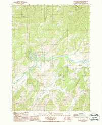
1987 Map of Oak Creek Valley
USGS Topo · Published 1987About this map
The North Fork Umpqua River snakes through this portion of Douglas County, carving the dramatic horseshoe curve at Whistlers Bend (County Park). In the late 1980s, this landscape shows a clear division between the winding river corridor and the agricultural and industrial activity concentrated in Oak Creek Valley. The terrain is defined by significant ridges and peaks including Bald Mountain, Jack Mountain, and Hog Mountain, which enclose the tributary drainages of Cooper Creek and Huntley Creek. Local infrastructure is marked by a small Quarry and a Sanitary Transfer Station, indicating the region's mid-century utility. Small family history clues appear in the form of a lone Cem and the V J Jackson County Wayside, reflecting the modest public and memorial sites established as the area grew beyond its early ranching roots.
Find a feature on this map
24 named features on this map. Tap any name to fly to it.
Don’t see what you’re looking for? This feature index may not catch every label — zoom into the map to look around manually.
Map Details
Editions of this 1987 Oak Creek Valley Map
This is the sole edition of this map. No revisions or reprints were ever made.
Other maps of this area

1897 · Roseburg
USGS Topo · 1:125,000

1900 · Roseburg
USGS Topo · 1:125,000

1954 · Dixonville
USGS Topo · 1:62,500

1954 · Sutherlin
USGS Topo · 1:62,500

1954 · Glide
USGS Topo · 1:62,500

1955 · Roseburg
USGS Topo · 1:62,500

1958 · Roseburg
USGS Topo · 1:250,000

1959 · Roseburg
USGS Topo · 1:250,000

1979 · Roseburg
USGS Topo · 1:100,000
1987 · Roseburg East
USGS Topo · 1:24,000