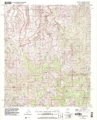
1996 Map of Oak Grove Canyon
USGS Topo · Published 2002About this map
Aravaipa Canyon Wilderness and the rugged Galiuro Mountains define this landscape along the Pinal and Graham County border. This area is characterized by a high concentration of historical mining activity in the southern reaches, where prospects and named mines like the Table Mtn Mine and Glory Hole Mine dot the drainage basins. The presence of Copper Creek (Site) near the confluence of Saloon Gulch and Copper Creek suggests an era of intense resource extraction and localized settlement.
Find a feature on this map
49 named features on this map. Tap any name to fly to it.
Don’t see what you’re looking for? This feature index may not catch every label — zoom into the map to look around manually.
Map Details
Editions of this 1996 Oak Grove Canyon Map
This is the sole edition of this map. No revisions or reprints were ever made.
Other maps of this area

1911 · Winkelman
USGS Topo · 1:125,000

1913 · Winkelman
USGS Topo · 1:125,000

1938 · Galiuro Mts
USGS Topo · 1:48,000

1938 · Klondyke
USGS Topo · 1:48,000

1943 · Galiuro Mts
USGS Topo · 1:62,500

1943 · Klondyke
USGS Topo · 1:62,500

1948 · Clark Ranch
USGS Topo · 1:24,000

1948 · Mammoth
USGS Topo · 1:62,500

1949 · Clark Ranch
USGS Topo · 1:24,000

1949 · Holy Joe Peak
USGS Topo · 1:62,500