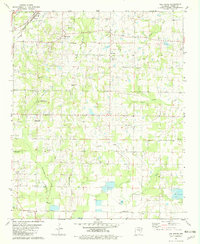
1982 Map of Oak Grove
USGS Topo · Published 1982About this map
Old Austin and the nearby Camp Nelson Confederate Cem anchor the northwestern portion of this landscape, where the Missouri Pacific railroad cuts through the terrain near Austin. The map reveals a high density of rural cemeteries and country churches, reflecting a deeply rooted local genealogy, including names like Monk, Glover, and Allison. This area of Lonoke County is defined by its water systems, particularly where Locust Bayou and Wattensaw Bayou converge with numerous smaller tributaries like Lick Creek and Pigeon Roost Creek. The presence of the Arkansas Holiness Encampment and several small settlements such as Sylvania and Oak Grove suggest a community-focused agricultural region. From the elevation at Smith Mtn to the Fish Farm operations in the southeast, the sheet documents the transition from small-town railroad hubs to an interior landscape of creeks and family homesteads.
Find a feature on this map
44 named features on this map. Tap any name to fly to it.
Don’t see what you’re looking for? This feature index may not catch every label — zoom into the map to look around manually.
Map Details
Editions of this 1982 Oak Grove Map
This is the sole edition of this map. No revisions or reprints were ever made.
Other maps of this area

1891 · Little Rock
USGS Topo · 1:125,000

1893 · Little Rock
USGS Topo · 1:125,000

1940 · Lonoke
USGS Topo · 1:62,500

1941 · Cabot
USGS Topo · 1:31,680

1943 · Jacksonville
USGS Topo · 1:31,680

1948 · Helena
USGS Topo · 1:250,000

1949 · Lonoke
USGS Topo · 1:62,500

1950 · Helena
USGS Topo · 1:250,000

1950 · Lonoke
USGS Topo · 1:62,500

1953 · Memphis
USGS Topo · 1:250,000