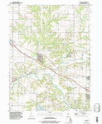
1997 Map of Oak Hill
USGS Topo · Published 1997About this map
The Jubilee College State Historic Site serves as the focal point of this Peoria County landscape, preserved within the broader Jubilee College State Park. Established in the mid-19th century as one of the first educational institutions in the region, the site's footprint is clearly delineated near the winding path of Kickapoo Creek. The surrounding terrain transitions from the structured layout of the historic college grounds to the more utilitarian landscapes of the Proving Ground and the Civil Defense Center to the southeast.
Find a feature on this map
31 named features on this map. Tap any name to fly to it.
Don’t see what you’re looking for? This feature index may not catch every label — zoom into the map to look around manually.
Map Details
Editions of this 1997 Oak Hill Map
This is the sole edition of this map. No revisions or reprints were ever made.
Other maps of this area

1893 · Dunlap
USGS Topo · 1:62,500

1898 · Dunlap
USGS Topo · 1:62,500

1905 · Peoria
USGS Topo · 1:62,500

1927 · Peoria
USGS Topo · 1:62,500

1930 · Glasford
USGS Topo · 1:62,500

1932 · Dunlap
USGS Topo · 1:62,500

1933 · Dunlap
USGS Topo · 1:62,500

1937 · Dunlap
USGS Topo · 1:62,500

1944 · Elmwood
USGS Topo · 1:62,500

1948 · Elmwood
USGS Topo · 1:62,500