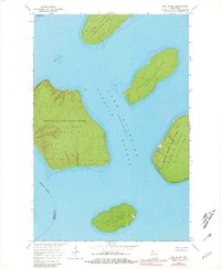
1963 Map of Oak Island
USGS Topo · Published 1981About this map
Lake Superior surrounds the northern reaches of the Apostle Islands in this mid-century topographic record, which depicts a landscape managed as the Apostle Islands State Forest. The map detail captures the isolated character of these landmasses, from the larger Oak Island and Stockton Island to the smaller Hermit Island and Otter Island. An industrial past is signaled by a quarry located on Hermit Island and another at Quarry Point, reflecting early extractive activities that preceded the area's transition toward conservation. Navigational hazards such as the Oak Island Shoal are charted alongside shoreline features like the Clay Banks and Bear Island, while the boundary between Ashland and Bayfield counties cuts through the open waters of the archipelago.
Find a feature on this map
15 named features on this map. Tap any name to fly to it.
Don’t see what you’re looking for? This feature index may not catch every label — zoom into the map to look around manually.
Map Details
Editions of this 1963 Oak Island Map
2 editions found
Other maps of this area

1941 · Bayfield
USGS Topo · 1:48,000

1946 · Bayfield
USGS Topo · 1:48,000

1953 · Ashland
USGS Topo · 1:250,000

1954 · Two Harbors
USGS Topo · 1:250,000

1957 · Two Harbors
USGS Topo · 1:250,000

1958 · Ashland
USGS Topo · 1:250,000

1958 · Two Harbors
USGS Topo · 1:250,000

1963 · Cat Island
USGS Topo · 1:24,000

1963 · Rocky Island
USGS Topo · 1:62,500

1963 · Oak Island
USGS Topo · 1:24,000