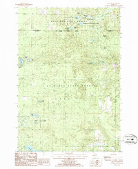
1986 Map of Oak Lake
USGS Topo · Published 1986About this map
The Fisheries Research Area along Hunt Creek defines the northern reaches of this mid-1980s terrain, where state-managed conservation lands dominate the landscape. This area, spanning the border of Montmorency and Oscoda counties, is characterized by a dense network of glacial kettle lakes and ponds. Traces of previous industrial activity appear as an Old RR Grade, which winds through the Au Sable State Forest and past the western shores of Oak Lake. These former rail paths, once used for timber extraction, now serve as structural markers through the wooded townships of Elmer and Clinton. The map documents a complex hydrology of interconnected waters, including East Fish Lake, Middle Fish Lake, and the expansive Bushman Swamp, illustrating the specialized environmental management that has long protected this section of Northern Michigan.
Find a feature on this map
30 named features on this map. Tap any name to fly to it.
Don’t see what you’re looking for? This feature index may not catch every label — zoom into the map to look around manually.
Map Details
Editions of this 1986 Oak Lake Map
This is the sole edition of this map. No revisions or reprints were ever made.
Other maps of this area

1949 · Lewiston
USGS Topo · 1:62,500

1950 · Lewiston
USGS Topo · 1:24,000

1950 · Comstock Hills
USGS Topo · 1:24,000

1951 · Comstock Hills
USGS Topo · 1:24,000

1951 · Lewiston
USGS Topo · 1:24,000

1954 · Traverse City
USGS Topo · 1:250,000

1955 · Comins
USGS Topo · 1:62,500

1958 · Traverse City
USGS Topo · 1:250,000

1963 · Red Oak
USGS Topo · 1:24,000

1972 · Mio
USGS Topo · 1:24,000