
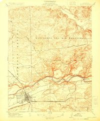
1915 Map of Oakdale
USGS Topo · Published 1915About this map
Oakdale emerges as a critical transportation hub in the northern San Joaquin Valley, defined by a dense intersection of three major rail lines including the Sierra Railway of California, the Southern Pacific, and the Atchison Topeka and Santa Fe. The landscape is dominated by the sprawling boundaries of the Rancheria Del Rio Estanislao and Thompson Rancho, reflecting the region's heritage of large land grants.
Find a feature on this map
28 named features on this map. Tap any name to fly to it.
Don’t see what you’re looking for? This feature index may not catch every label — zoom into the map to look around manually.
Map Details
Editions of this 1915 Oakdale Map
2 editions found
Other maps of this area

1915 · Trigo
USGS Topo · 1:31,680

1915 · Paulsell
USGS Topo · 1:31,680

1915 · Thalheim
USGS Topo · 1:31,680

1916 · Riverbank
USGS Topo · 1:31,680

1916 · Waterford
USGS Topo · 1:31,680

1916 · Bachelor Valley
USGS Topo · 1:31,680

1916 · Copperopolis
USGS Topo · 1:62,500

1939 · Modesto East
USGS Topo · 1:62,500

1942 · Farmington
USGS Topo · 1:62,500
1942 · Modesto East
USGS Topo · 1:62,500