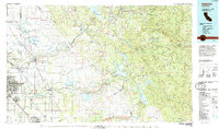
1994 Map of Oakdale
USGS Topo · Published 1995About this map
The Stanislaus National Forest and the rugged foothills of the Sierra Nevada dominate the eastern portion of this mid-1990s landscape, while the western half transitions into the intensive irrigation networks of the Central Valley. Major water engineering projects define the region's geography, including the Don Pedro Reservoir, New Melones Lake, and the critical Hetch Hetchy Aqueduct which cuts across the terrain toward the coast.
Find a feature on this map
87 named features on this map. Tap any name to fly to it.
Don’t see what you’re looking for? This feature index may not catch every label — zoom into the map to look around manually.
Map Details
Editions of this 1994 Oakdale Map
2 editions found
Other maps of this area

1889 · Jackson
USGS Topo · 1:125,000

1891 · Big Trees
USGS Topo · 1:125,000

1892 · Jackson
USGS Topo · 1:125,000

1893 · Sonora
USGS Topo · 1:125,000

1894 · Big Trees
USGS Topo · 1:125,000

1894 · Lodi
USGS Topo · 1:125,000

1896 · Dardanelles
USGS Topo · 1:125,000

1896 · Sonora
USGS Topo · 1:125,000

1897 · Jackson
USGS Topo · 1:125,000

1897 · Sonora
USGS Topo · 1:125,000