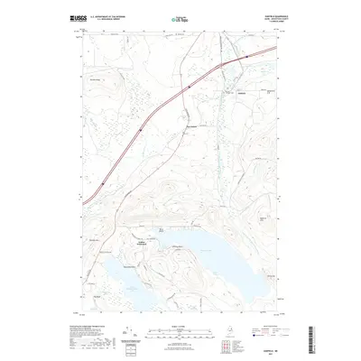
2021 Map of Oakfield
USGS Topo · Published 2021About this map
Upper Mattawamkeag Lake and Pleasant Lake anchor the southern landscape of this Aroostook County survey, where the East Branch Mattawamkeag River flows through a terrain of ridges and peaks like DeLette Ridge and Robinson Mtn. The settlement pattern follows the corridor of Rte 2 and the interstate, connecting the communities of Oakfield and Dyer Brook. Genealogists will find several notable burial sites, including Oakfield Cem, Dyer Brook Cem, and the Barrows Chambers Cem. In the central hills, the Walker Settlement is situated near Birch Point, surrounded by a network of local routes such as Thompson Settlement and Dow Farm Rd. The map illustrates the region's aquatic complexity, from the secluded Lost Pond to the wide reaches of Sand Cove, set against the backdrop of Outlet Mtn.
Find a feature on this map
60 named features on this map. Tap any name to fly to it.
Don’t see what you’re looking for? This feature index may not catch every label — zoom into the map to look around manually.
Map Details
Editions of this 2021 Oakfield Map
This is the sole edition of this map. No revisions or reprints were ever made.
Other maps of this area

1937 · Smyrna Mills
USGS Topo · 1:62,500

1940 · Island Falls
USGS Topo · 1:62,500

1940 · Sherman
USGS Topo · 1:62,500

1941 · Mattawamkeag Lake
USGS Topo · 1:62,500

1942 · Island Falls
USGS Topo · 1:62,500

1942 · Sherman
USGS Topo · 1:62,500

1943 · Mattawamkeag Lake
USGS Topo · 1:62,500

1954 · Presque Isle
USGS Topo · 1:250,000

1954 · Millinocket
USGS Topo · 1:250,000

1955 · Smyrna Mills
USGS Topo · 1:62,500