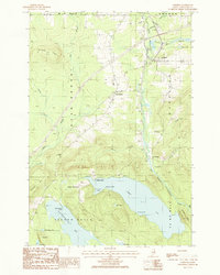
1986 Map of Oakfield
USGS Topo · Published 1986About this map
Oakfield serves as a primary hub of rail activity in southern Aroostook County, marked by extensive trackage including 12 Tracks and 8 Tracks near the town center. The landscape is defined by the convergence of the East Branch Mattawamkeag River and several tributary brooks, such as Huntley Brook and Moose Brook. Settlement patterns follow the river valleys and ridges, with the Walker Settlement and the small community at Dyer Brook punctuating the wooded terrain.
Find a feature on this map
42 named features on this map. Tap any name to fly to it.
Don’t see what you’re looking for? This feature index may not catch every label — zoom into the map to look around manually.
Map Details
Editions of this 1986 Oakfield Map
This is the sole edition of this map. No revisions or reprints were ever made.
Other maps of this area

1937 · Smyrna Mills
USGS Topo · 1:62,500

1940 · Island Falls
USGS Topo · 1:62,500

1940 · Sherman
USGS Topo · 1:62,500

1941 · Mattawamkeag Lake
USGS Topo · 1:62,500

1942 · Island Falls
USGS Topo · 1:62,500

1942 · Sherman
USGS Topo · 1:62,500

1943 · Mattawamkeag Lake
USGS Topo · 1:62,500

1954 · Presque Isle
USGS Topo · 1:250,000

1954 · Millinocket
USGS Topo · 1:250,000

1955 · Smyrna Mills
USGS Topo · 1:62,500