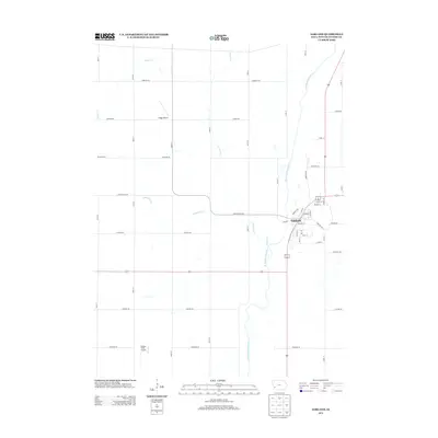
2013 Map of Oakland
USGS Topo · Published 2013About this map
Oakland sits on the eastern bank of the W Nishnabotna River, serving as a central hub for this portion of Pottawattamie County. The river corridor defines the local topography, with several smaller tributaries like Slocum Cr, Minimum Cr, and Mud Cr carving paths through the agricultural land. This survey captures the layout of the town's residential streets, including Walnut St, Main St, and Oakland Ave, which connect the community to the surrounding farmland. Beyond the town limits, the landscape is organized by a precise grid of county roads such as Lombardy Rd and Juniper Rd. The inclusion of small-scale aviation sites like Ridge Airport and Volkens Field Airport indicates the importance of private flight in this rural Iowa setting, providing unique landmarks for local history researchers and genealogists tracing family properties.
Find a feature on this map
43 named features on this map. Tap any name to fly to it.
Don’t see what you’re looking for? This feature index may not catch every label — zoom into the map to look around manually.
Map Details
Editions of this 2013 Oakland Map
This is the sole edition of this map. No revisions or reprints were ever made.
Other maps of this area

1954 · Omaha
USGS Topo · 1:250,000
1956 · Neola
USGS Topo · 1:24,000
1956 · Treynor
USGS Topo · 1:24,000

1957 · Omaha
USGS Topo · 1:250,000
1957 · Taylor
USGS Topo · 1:24,000

1958 · Omaha
USGS Topo · 1:250,000
1963 · Avoca NW
USGS Topo · 1:24,000
1963 · Avoca SE
USGS Topo · 1:24,000
1963 · Oakland
USGS Topo · 1:24,000
1963 · Avoca
USGS Topo · 1:24,000